 Global momentum towards zero-emissions vehicle (ZEV) adoption has continued to accelerate over the last year. For 2022, annual passenger electric vehicle (EV) sales were on track for around 10.6 million units, up from 3.1 million in 2020 and 6.6 million in 2021, according to a November 2022 report from Bloomberg New Energy Finance. Moreover, some assert that a tipping point has already been reached, with 5 percent of new U.S. car sales being EVs.
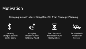
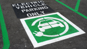
With the market share of EVs continuing to grow, there is a nationwide call to establish robust charging infrastructure and electric vehicle supply equipment (EVSE) needed to fuel the electrification of transportation in the United States. Utilities and fleet technology companies are still in the early stages of deployment, and charger site selection is a multi-criteria process with varying considerations for each site.
 To help planners and developers select the perfect site to fit their needs, the North Carolina Clean Energy Technology Center (NCCETC) at NC State University recently developed a customizable tool for prioritizing the placement of EV chargers. The EVSE Suitability GIS product is not only able to consider several variables relevant to determining charging infrastructure siting benefits, but also has a custom weighting function so developers can tailor the weight of each variable being considered to their unique situation. The GIS product was created using data for the five counties covered by Roanoke Electric Cooperative: Bertie, Gates, Halifax, Hertford, and Northampton.
NCCETC’s Alexander Yoshizumi coordinated with Roanoke Electric Cooperative (REC) while creating the EVSE Suitability GIS tool, identifying factors to include in the suitability tool in addition to the approximate weight that each factor should be given. Last month, Yoshizumi presented the results and deliverables of the project to REC staff and lent his expertise to ensure a seamless transfer of the EVSE Suitability GIS tool.
“Tools like these are going to be invaluable for selecting charging sites that are sustainable and accessible while helping meet community needs and statewide sustainability goals,” said Yoshizumi. North Carolina’s Executive Order 246 established goals to reduce economy-wide greenhouse gas emissions by 50 percent no later than 2030 and increase the number of registered ZEVs to at least 1.25 million by 2030.
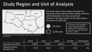 The EVSE Suitability GIS tool enables utilities and other EVSE developers to efficiently and accurately determine site suitability with the flexibility to explore alternative weighting schemes. For the scope of NCCETC’s project, the suitability tool was applied over a 5-county region that REC serves, and several variables of interest to include were determined according to REC.
Yoshizumi explained how this tool differs from others in that it pairs customizable variable weighting with a fine scale unit of analysis, providing a much more granular understanding of where suitability is highest. For example, the Regional EV Charging Infrastructure Location Identification Toolkit uses the census tract as its unit of analysis. “Not only can census tracts vary substantially in size, but many are also of a coarse resolution,” stated Yoshizumi. The median census tract area in North Carolina is approximately 369 acres, whereas the EVSE Suitability GIS product’s unit of analysis is just 40 acres.
“Prioritizing charging sites is a complex process and, for each site, there are a variety of factors to consider and weigh for an accurate depiction of the site’s value,” noted Yoshizumi. The variables of interest were grouped into five categories: infrastructure, population and vehicle density, hazards, equity and other points of interest.
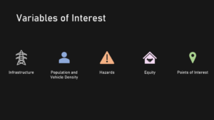 Infrastructure variables of interest included data on existing EVSE, roads and highways, proximity to interchanges, and electric grid accessibility and interconnection capabilities. The geographic distribution of EVs is not uniform, so population and vehicle density can be valuable for identifying opportunities to construct new EV charging infrastructure.
“For REC’s territory in particular, in eastern North Carolina, flooding is a key concern that could limit site access or damage installed equipment, so the tool can take this hazard into consideration, too,” Yoshizumi said.
 Points-of-interest in the EVSE Suitability GIS product can indicate businesses or amenities that could be valuable to the public like nearby parks or restaurants that can occupy a driver’s time while they wait to charge. Another consideration is that certain types of points-of-interest are more likely to coincide with facilities, safety and visibility such as access to public restrooms or parking areas monitored by surveillance cameras.
As EVSE developers map out charging infrastructure and EVSE locations, they will need to maximize site selection to support an equitable and swift transition to zero-emission vehicles. “By incorporating all of these datasets into one adaptable tool, users can explore multiple scenarios with different priority weights with ease,” stated Yoshizumi.
The staff behind NCCETC’s Clean Transportation program are committed to helping diversify fuel supplies and support cleaner, more vibrant local and state economies. The end result – cleaner air and greater energy security for all.